
A False Start
I started the research for this chapter of ‘Gledhow and Me’ by asking myself this question:
Has the underlying geology of the area had as much impact
as the ‘accident of history’?
My plan was firstly to focus on geology and then to ‘widen the search’ – go on to look into a range of other possible factors, specifically those which relate to the land itself. But the disadvantage of starting to look at ‘geology’ is that there’s a lot of it in Yorkshire! As the image below attests, there are a lot of highly visible, very dramatic rock formations and cliffs.
And instead of concentrating on my immediate environs I was distracted by the memory of our car toiling its way up Sutton Bank (some 50 miles away); by the sheer limestone cliffs at Malham Cove, (40 miles away); the river rushing through the rocks of The Strid by Bolton Abbey (30 miles); Brimham Rocks (20 miles); The Cow and Calf Rocks (15 miles); Almscliffe Crag (a mere 10 miles); as well as by the nearby cliffs – Otley Chevin, Pool Bank and Harewood Bank.
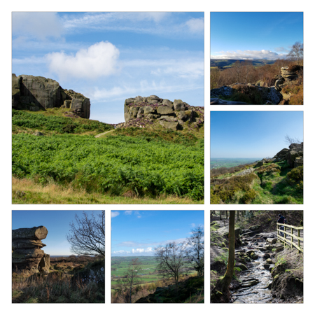
The Cow and Calf Rocks (main image)
with Otley Chevin, the Chevin Forest and Brimham Rocks
The most local features I considered in this somewhat erratic, personalised geological review were the two that I mentioned in Chapter 1, firstly nearby Gledhow Valley which is a RIGS site – a Regionally Important Geological and Geomorphological Site (please don’t ask me about geomorphological’) – and secondly the Roundhay Park Fault which runs east-west across the park and passes within a mile of our home. But I confess my interest and engagement with them was based on surprise that we live amongst ‘real’ geology, rather than their possible geological significance.
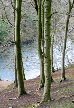
The steep sides of Gledhow Valley
Inevitably I turned to Google for assistance on the topic of the Roundhay Park Fault and its ‘search’ was comprehensive but incomprehensible! I was overwhelmed by an avalanche of unfamiliar terms – the Namurian Epoch, the Upper Carboniferous age, the Upper Permian age; sandstones, shales, Millstone Grit, Elland Flags, coal measures, magnesian limestone – as well as course-finder information from the University of Leeds for a degree in geology.
I made a modicum of progress when I found the British Geological Survey Map online, overlaid as it is on a normal street map. It allowed me to orientate myself by following the “superficial silt deposits” along the River Aire and the Aire Valley; along Adel Beck, Meanwood Beck and Sheepscar Beck through the Meanwood Valley; along Gledhow Beck and through Gledhow Valley; and finally, along Great Heads Beck, through the Roundhay Gorge and into Wyke Beck.
Then it was easy to find Gledhow and our road on the bedrock-map (below), located in an ‘island’ of green – representing a bedrock of Elland Flags sandstone apparently – the northern edge being created by the legendary(!) Roundhay fault line and the western edge by Gledhow Valley. But I floundered again under a deluge of geological terminology – a problem I felt compelled to overcome.
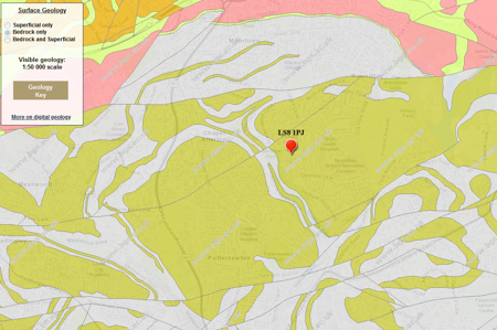
Bedrock Map of the locality (with our postcode marked in red)
Screenshot from BGS Geology Viewer © British Geological Survey
So my next step was to take advantage of the Open University’s online ‘taster’ course, ‘An Introduction to Geology’ – at 12 study-hours it seemed quicker than embarking on another 3-year degree course, and cheaper too (it was free!) And I had an absorbing week being introduced to even more unfamiliar terminology, as well as an abundance of fascinating information – for example, that the British Isles were formed from the drift and collision of two (maybe three) continental land masses which had originally been thousands of miles apart.
At that point I realised that I’d made a false start with ‘geology’ – interesting though it was – because I couldn’t find a physical, hands-on link that helped me relate ‘my Gledhow’ with the geology of its underlying rock formations. (As an example, the dramatic-sounding Roundhay Park Fault is, in fact, the least visible of the local features!) But fortunately I’d read enough to understand that there is a more immediate, hands-on element – or more strictly, a feet‑on element – if I turned my attention towards the ‘lie of the land’, to the physical features of the high ground, the valleys and the becks.
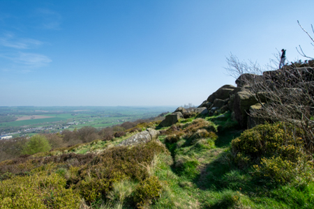
The view from Otley Chevin, looking north across the Wharfe valley.
Almscliffe Crag is just(?) visible on the horizon
My interest in ‘geology’ was therefore replaced by a focus on ‘topography’ and ‘relief’ – whilst pausing only long enough to revise my study-question:
Have the topography and relief had as much impact as the ‘accident of history’ that Steven Burt refers to?
And then to confirm that I fully understood the terminology – that it fitted with my notion of the ‘lie of the land’.
“The topography of a particular area is its physical shape, including its hills, valleys, and rivers.” (Collins Dictionary)
“Relief is the term used for the differences in height from place to place on the land’s surface … It is greatly affected by the underlying geology [and] … relies on the hardness, permeability and structure of a rock.” (British Geological Survey)