
My Space
By now I wanted to give ‘my space’ some physical reality and visibility. After all, I'd been talking quite casually about the Gledhow and Roundhay area, but I hadn’t stopped to fully describe or define the area that I carry in my mind. So I moved onto impromptu map making – drawing ‘my space’ out on an Ordnance Survey map (below).
[As I drew ‘my space’ out on the map, I developed a clear sense of it comprising an interior, a perimeter and a surrounding annulus – or inner-lands, edge‑lands and outer‑lands as I call them – a concept I’ll return to in Chapter 3].
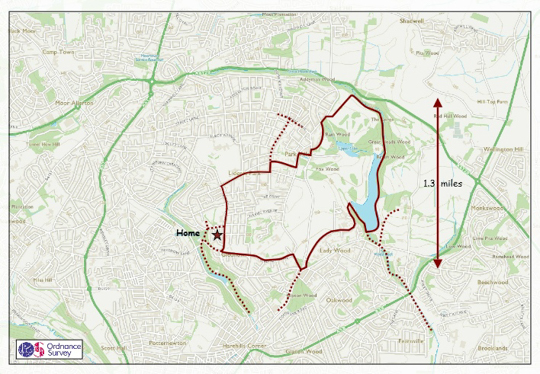
Gledhow and Roundhay – defining ‘My Space’
The solid line describes the area covered by our regular walks (particularly when
Covid restrictions allowed), the dotted lines less frequent walks
Basic map © Ordnance Survey
Then taking a fictional walk clockwise around its boundary, I imagined I had set off from home, walked up the road and I was standing by the doctors’ surgery (at the top left corner), looking northwards, down on the allotments and on Allerton Grange School; then I continued to the north east until I was at the edge of Roundhay Park Golf Course (top right corner) looking down into Roundhay Gorge.
Mentally, I took a short-cut though the park and stood looking south from The Mansion down to Waterloo Lake and the city, and then looking down from Hill 60 into The Bowl – once known as Roundhay Park Velodrome. And at last I reached the southern side of ‘my space’ and was looking down the hill to the Tesco supermarket (bottom centre); and then I was standing at the top of ‘Little Switzerland’ – Lidgett Hill – (bottom left corner) looking down into a tree-lined ‘tunnel’ that leads to Gledhow Valley.
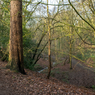
Looking down into Roundhay Gorge
You can see the operative phrase here – looking down – in fact there was so much looking down that the image of an upturned dish filled my mind, with a plateau as its base and steep sided edges. And this subjective interpretation was confirmed (well, mostly confirmed) when I drew the same boundary on to a topographic map (below). Most of ‘my space’ – the plateau – is shown in yellow and red (i.e. land over 105m above mean sea level) whereas the sides fall away into the greens and blues of lower-lying land, particularly on the south side.
Unexpectedly, my dish-shaped analogy falls down along the northern edge of the plateau – unexpected because the boundary of ‘my space’ follows the great(!) Roundhay Park Fault. Here the topographic changes are the least obvious, and the transition across the boundary (from inner-lands to outer-lands) contrasts with majority of the ‘dish’ because the land rises slightly to the north, instead of falling away. So now it made sense to abandon the idea of a ‘dish’ – to accept that its usefulness had passed – and replace it with the analogy of an island, bearing in mind that, for me, there is also a sense that ‘my space’ acts as a sanctuary.
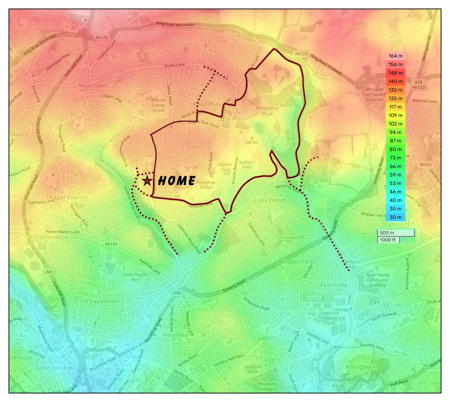
A topographic map of ‘My Space’
© topographic-map.com